An early start to the day in Grasmere, as we left the hostel shortly after 7:00. But before we started the rambling in earnest, we stopped at St. Oswald's, where Wordsworth worshipped. Two pictures, the first one suitably softened into the Romantic early mist.
This second, rather more prosaic, picture captures one of the key trends within British Christianity in the last few decades: the decline of denominational conflict
After being disappointed by the still-closed bakery (what kind of bakery isn't open by 7 AM?!), we started the walk proper. Up and over a little ridge to rejoin the Cumbria Way at Chapel Stile. From the top of the ridge the main view was a rather unsightly slate quarry, but by the time we reached the valley floor the quarry disappeared from view and picturesque-ness returned.
We stopped by a small stream for a bit of breakfast: pita, cheese, and gorp. Then it was into the valley of Great Langdale. Our guidebook told of the tremendous views of the Langdale Pikes to the north, but the cloud cover kept them pretty obscured. We did, however, see plenty of sheep, like this friendly pair.
Four miles into the day we arrived at the Old Dungeon Ghyll Hotel, a famous destination for Lake District hill-walkers and climbers, complete with the Hikers' Bar watering hole. We dropped off our big bag at the hotel, then had a look at the weather forecast for the day.
The initial plan for the day was arrive at ODG early enough to make it to Scafell Pike and back. But 14 miles of serious hiking with less than a 10% chance of views from the summit (coupled with gloomy skies in Great Langdale) dissuaded us from climbing England's highest mountain. Instead, we opted for a walk that kept us closer to "home," ascending High Raise, described in our guidebook as the "overlord" of the Langdales.
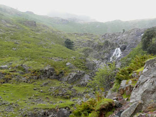
The ascent up High Raise had three distinct phases. First was a steep but well-traveled path following Stickle Ghyll to a waterfall. This part of the climb was full of other hikers, including some young children with impressive hardiness - we overheard no whining about the rain. The power of the waterfall is rather poorly captured in this photograph, but it at least provides a sense of the terrain.
Just above the waterfall, at an elevation of approximately 1,500 feet, is Stickle Tarn, a small lake that was dammed in the early 19th century. Towering over the tarn is the imposing face of Pavey Ark.
After Stickle Tarn, the path upwards became a lot more lonely, and also much less clear. No longer able to just follow the stream up, we had to use our compass and handy Ordnance Survey map. About two-thirds of the way up this section of the climb, we were crossed paths with another hiker who had been bounding ahead of us. "You can't see jack from up there," he warned us, as he rather gloomily passed us by. But at this point we were committed to making it to the top, so we continued upward.
The next clear stopping-point was Sergeant Man, a subsidiary peak of High Raise. The clouds actually did roll away enough for us to get a nice view of the valley below, though they continued to enshroud the high peaks in the distance.
From Sergeant Man, the final ascent to High Raise was nothing more than a short walk, with a barely perceptible change in elevation. Given the mist that had settled on the summit, I'm not sure that we would have found the summit cairn without a clear compass heading to follow. Here I am at the summit of High Raise at 762 meters.
Our plan from this point had been to descend back into the valley via some other peaks, bagging Thunacar Knott, Pavey Ark, Harrison Stickle, Pick o'Stickle, and Loft Crag along the way. But that would have involved finding a different path down the western slope of High Raise. Given the mist, lack of landmarks (we even struggled a bit finding our way back to Sergeant Man), and advancing hour, we decided to just descend the way we had come up. A bit below the tarn, the clouds finally cleared enough to allow a decent photograph of the valley below.
From there, back to the hotel to check in and enjoy a hot shower. Dinner at the Hikers' Bar was disappointing (not least because they didn't actually have either of the menu items I order), but sometimes, as a vegetarian, you just have to accept your fate. At least the stilton and broccoli soup was flavorful and warming.
We had a long day to Keswick in front of us, so early to bed...
Approximately 10 miles walked
Towns: Grasmere, Chapel Stile
Peaks: Sergeant Man, High Raise


No comments:
Post a Comment